

C-MAP MAX NA-M321 - Cape Henry, NC-Apalachicola, FL - SD™ Card
| Manufacturer | C-MAP | |
| MFG NO | NA-M321SDCARD | |
| SKU | 6051723 | |
| UPC |
- SUMMARY
- SPECIFICATIONS
- MANUFACTURER
- REVIEWS
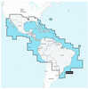
NA-M321 => Cape Henry to Apalachicola BayCoverage includes offshore bathymetric details from Cape Henry, VA to Apalachicola Bay, FL. Coverage extends from the coastline out to the offshore Atlantic Canyons - Norfolk, Washington and others. Some coverage of the Bahamas is also included, covering western Northwest Providence Channel and the banks and shoals around Bimini. Fishing Contour Charts do not include coastal navigational features and are recommended for offshore fishing only
| Specification | Value | |
|---|---|---|
| MFG NO | NA-M321SDCARD | |
| SKU | 6051723 | |
| UPC |
| C-MAP | ||
| Phone: | ||
| Email: | us-customersupport@c-map.com | |
| Website: | http://www.c-map.com | |
| Address: |
, |
|

|
Garmin BlueChart; g3 HD - HXUS604x - US All & Canadian West - microSD™/SD™BlueChart® g3 HD - HXUS604x - US All & Canadian West - microSD™/SD™CoverageProvides detailed coastal coverage of the U.S., including the East Coast from Key West, FL, to the Canadi... |
||||||
|
FLAT SHIPPING!
|
|||||||
|
PRICE $197.99
QTY
ADD TO CART
|
|||||||
|
Garmin Navionics+™ Nssa004l - Mexico, The Caribbean To Brazil - Inland & Coastal Marine ChartNavionics+™ NSSA004L - Mexico, the Caribbean to Brazil - Inland & Coastal Marine ChartGet the world’s No. 1 choice in the marine mapping with the best, most up-to-date Navionics®+ ... |
||||||
|
FLAT SHIPPING!
|
|||||||
|
PRICE $134.99
QTY
ADD TO CART
|
|||||||
|
Garmin Navionics Vision+™ Nvus008r U.s. WestGarmin Navionics Vision+™ NVUS008R U.S. WestGet the world’s No. 1 choice in the marine mapping (based on 2020 reported sales) — with the best, most up-to-date Navionics®+ cartogr... |
||||||
|
FLAT SHIPPING!
|
|||||||
|
PRICE $134.99
QTY
ADD TO CART
|
|||||||
C-MAP MAX NA-M321 - Cape Henry, NC-Apalachicola, FL - SD™ Card
NA-M321 => Cape Henry to Apalachicola BayCoverage includes offshore bathymetric details from Cape Henry, VA to Apalachicola Bay, FL. Coverage extends from the coastline out to the offshore Atlantic Canyons - Norfolk, Washington and others. Some coverage of the Bahamas is also included, covering western Northwest Providence Channel and the banks and shoals around Bimini. Fishing Contour Charts do not include coastal navigational features and are recommended for offshore fishing only
Manufacturer C-MAP
Mfg No NA-M321SDCARD
SKU 6051723
UPC


| 0 | Total: $0.00 |
|
|

