

Garmin Gpsmap® 1243xsv Combo Gps/fishfinder Gn+ W/gmr 18hd+
| Manufacturer | Garmin | |
| MFG NO | 010-02367-80 | |
| SKU | 6232968 | |
| UPC | 753759285289 |
- SUMMARY
- SPECIFICATIONS
- MANUFACTURER
- REVIEWS
GPSMAP® 1243xsv Combo GPS/Fishfinder GN+ with GMR 18HD+You’re an angler who wants premium features, maps, and charts for your connected helm, plus built-in sonar. This crisp 12" high-resolution chartplotter makes that wish come true.Get a sharper view from your connected helm with the GPSMAP® 1243xsv chartplotter. With its high-resolution 12” in-plane switching display, ultra-sleek design, and vivid sonar color palette, it seamlessly integrates into your Garmin marine system. GPSMAP 1243xsv also features built-in Ultra High-Definition SideVü™ and ClearVü™ scanning sonars and supports 1 kW CHIRP traditional sonar as well as fully networkable radar and live sonar devices. Preloaded Garmin Navionics+™ coastal charts and inland mapping feature Auto Guidance+™ technology (Auto Guidance+ is for planning purposes only and does not replace safe navigation operations) for helping you get where you need to go. Plus, there’s support for optional Garmin Navionics Vision+™ premium map content. Easily build your marine system — from compatible sonar and autopilots to compatible radar, cameras, and multimedia — by using HTML 5.0, NMEA 2000® and NMEA 0183 network connectivity, J1939 for engines, and the Garmin Marine Network. Or pair your plotter with your other compatible Garmin devices, such as quatix® marine smartwatches, wind transducers, wireless remote controls, and more. Features:High-resolution in-plane switching touchscreen display offers improved sunlight readability and wide-angle visibility over previous-generation 12” units Fast and responsive, this robust GPSMAP® system references 10 Hz GNSS (GPS, GLONASS, and Galileo) for accurate positioning and smooth speed as well as COG data Slimline display borders, edge-to-edge glass, and reduced unit footprint make for easy retrofit in a wider range of dash configurationsPreloaded Garmin Navionics+™ coastal charts and inland mapping feature Auto Guidance+™ technology (Auto Guidance+ is for planning purposes only and does not replace safe navigation operations); plus, there’s support for optional Garmin Navionics Vision+™ premium map content. J1939 engine connectivity for easy integration with engines and our exclusive OneHelm™ feature for connecting to your compatible third-party devices, such as EmpirBus™ digital switchingEasily build your marine system — from compatible sonar and autopilots to compatible radar, cameras and multimedia — by using NMEA 2000® and NMEA 0183 network connectivity and the Garmin Marine NetworkUse built-in Wi-Fi® networking to pair with the free ActiveCaptain® smartphone app for access to the OneChart™ feature, smart notifications, software updates, and more. Integrated ANT® connectivity support for use with your compatible quatix® marine smartwatches, gWind™ Wireless 2 transducer, GNX™ Wind marine instrument, and wireless remote controlsBuilt-in Ultra High-Definition SideVü™ and ClearVü™ scanning sonars with high-contrast vivid color palettes to help distinguish fish from structure Supports live sonar devices, 1 kW CHIRP traditional sonar, and moreWhat's In The Box?ChartplottermicroSD preinstalledPower cable NMEA 2000 T-connectorNMEA 2000 drop cableBail mount with knobsFlush mount kit with gasketProtective coverTrim piece snap coversDocumentationGPSMAP x3 chartplotters are preloaded with Garmin Navionics+ offshore, coastal, and inland water charts for the U.S. and CanadaWARNING: This product can expose you to chemicals including NICKEL (METALLIC) which is known to the State of California to cause cancer. For more information go to P65Warnings.ca.gov.
| Specification | Value | |
|---|---|---|
| MFG NO | 010-02367-80 | |
| SKU | 6232968 | |
| UPC | 753759285289 |
| Garmin | ||
| Phone: | 913-397-8200 | |
| Email: | ||
| Website: | http://www.garmin.com | |
| Address: |
1200 East 151st Street Olathe, KS 66062 |
|
|
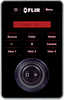
FLIR JCU-2 Joystick ControllerJCU-2 Joystick ControllerThe joystick is the primary control for the M400 & M400XR and the M300 series (M300C, M332, M364, M364C, and M364C LR. It is used to wake the system or put it in standby, ... |
||||||
|
FLAT SHIPPING!
|
|||||||
|
PRICE $1,467.17
QTY
ADD TO CART
|
|||||||
|
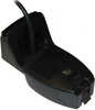
Si-tex 492/50/200st Transom Mount Transducer F/es502SI-TEX 492/50/200ST Transom Mount Transducer f/ES502 Dual Frequency 50/200 kHz Max Power: 500W Beam Angle: 42 deg. @ 50 kHz, 12 deg. @ 200 kHz Housing: Plastic Mount: Transom Plug: 8 Cable: 30' Temp:... |
||||||
|
FLAT SHIPPING!
|
|||||||
|
PRICE $227.99
QTY
ADD TO CART
|
|||||||
Garmin Gpsmap® 1243xsv Combo Gps/fishfinder Gn+ W/gmr 18hd+
GPSMAP® 1243xsv Combo GPS/Fishfinder GN+ with GMR 18HD+You’re an angler who wants premium features, maps, and charts for your connected helm, plus built-in sonar. This crisp 12" high-resolution chartplotter makes that wish come true.Get a sharper view from your connected helm with the GPSMAP® 1243xsv chartplotter. With its high-resolution 12” in-plane switching display, ultra-sleek design, and vivid sonar color palette, it seamlessly integrates into your Garmin marine system. GPSMAP 1243xsv also features built-in Ultra High-Definition SideVü™ and ClearVü™ scanning sonars and supports 1 kW CHIRP traditional sonar as well as fully networkable radar and live sonar devices. Preloaded Garmin Navionics+™ coastal charts and inland mapping feature Auto Guidance+™ technology (Auto Guidance+ is for planning purposes only and does not replace safe navigation operations) for helping you get where you need to go. Plus, there’s support for optional Garmin Navionics Vision+™ premium map content. Easily build your marine system — from compatible sonar and autopilots to compatible radar, cameras, and multimedia — by using HTML 5.0, NMEA 2000® and NMEA 0183 network connectivity, J1939 for engines, and the Garmin Marine Network. Or pair your plotter with your other compatible Garmin devices, such as quatix® marine smartwatches, wind transducers, wireless remote controls, and more. Features:High-resolution in-plane switching touchscreen display offers improved sunlight readability and wide-angle visibility over previous-generation 12” units Fast and responsive, this robust GPSMAP® system references 10 Hz GNSS (GPS, GLONASS, and Galileo) for accurate positioning and smooth speed as well as COG data Slimline display borders, edge-to-edge glass, and reduced unit footprint make for easy retrofit in a wider range of dash configurationsPreloaded Garmin Navionics+™ coastal charts and inland mapping feature Auto Guidance+™ technology (Auto Guidance+ is for planning purposes only and does not replace safe navigation operations); plus, there’s support for optional Garmin Navionics Vision+™ premium map content. J1939 engine connectivity for easy integration with engines and our exclusive OneHelm™ feature for connecting to your compatible third-party devices, such as EmpirBus™ digital switchingEasily build your marine system — from compatible sonar and autopilots to compatible radar, cameras and multimedia — by using NMEA 2000® and NMEA 0183 network connectivity and the Garmin Marine NetworkUse built-in Wi-Fi® networking to pair with the free ActiveCaptain® smartphone app for access to the OneChart™ feature, smart notifications, software updates, and more. Integrated ANT® connectivity support for use with your compatible quatix® marine smartwatches, gWind™ Wireless 2 transducer, GNX™ Wind marine instrument, and wireless remote controlsBuilt-in Ultra High-Definition SideVü™ and ClearVü™ scanning sonars with high-contrast vivid color palettes to help distinguish fish from structure Supports live sonar devices, 1 kW CHIRP traditional sonar, and moreWhat's In The Box?ChartplottermicroSD preinstalledPower cable NMEA 2000 T-connectorNMEA 2000 drop cableBail mount with knobsFlush mount kit with gasketProtective coverTrim piece snap coversDocumentationGPSMAP x3 chartplotters are preloaded with Garmin Navionics+ offshore, coastal, and inland water charts for the U.S. and CanadaWARNING: This product can expose you to chemicals including NICKEL (METALLIC) which is known to the State of California to cause cancer. For more information go to P65Warnings.ca.gov.
Manufacturer Garmin
Mfg No 010-02367-80
SKU 6232968
UPC 753759285289

- Reloading
- Ammunition
- Optics
-
All Departments
- Air Guns & Accessories
- Ammunition
- Ammunition Accessories
- AR-15 Parts and Accessories
- Archery, Crossbows & Accessories
- Baseball and Softball Products
- Bikes and Scooters
- Blowguns and Sling Shots
- Books, Maps, and Videos
- Camping Gear
- Chemicals
- Choke Tubes & Tube Cases
- Climbing Gear
- Clothing, Hunting Apparel, and Footwear
- Electronics, Metal Detectors, GPS, Game Cameras, and Radios
- Eye and Hearing Protection
- Firearm Parts and Firearm Accessories
- Fishing Gear
- Flashlights, Lanterns, Lighting, and Head Lamps
- Food Preparation
- Gifts, Games, Toys, and Promotional Items
- Golf Products
- GPS Devices
- Gun Cases Rifle, Pistol, and Shotgun
- Gun Cleaning and Care Products
- Gun Safes & Accessories
- Gunsmithing Equipment and Products
- Health, Fitness, and First Aid Products
- Holsters & Accessories
- House and Cabin
- Hunting and Safari Trips
- Hunting Gear
- Insect Control
- Knives, Saws, Axes, and Accessories
- Lacrosse Products
- Law Enforcement and Training
- Marine and Boating
- Muzzleloaders, Accessories and Supplies
- New Products
- Night Vision and Thermal Vision Equipment
- Optics
- Pet Products
- Range Bags, Fanny Packs, Day Pack, Stuff Sack and Specialty Bags and Cases
- Reloading
- Shooting Gear
- Snap Caps and Dummy Ammuntition
- Targets & Throwers
- Travel Products
- Vehicle Accessories, ATV Accessories, and Game Carriers
- Water Sports Equipment
- Winter Gear and Accessories
- Winter Sports Equipment
- Zombie Gear
- Today's Deals
- LG-Outdoors Blog
- Craig Boddington on Calibers
- Fit Charts
- Search By Department
- Air Guns & Accessories
- Ammunition
- Ammunition Accessories
- AR-15 Parts and Accessories
- Archery, Crossbows & Accessories
- Baseball and Softball Products
- Bikes and Scooters
- Blowguns and Sling Shots
- Books, Maps, and Videos
- Camping Gear
- Chemicals
- Choke Tubes & Tube Cases
- Climbing Gear
- Clothing, Hunting Apparel, and Footwear
- Electronics, Metal Detectors, GPS, Game Cameras, and Radios
- Eye and Hearing Protection
- Firearm Parts and Firearm Accessories
- Fishing Gear
- Flashlights, Lanterns, Lighting, and Head Lamps
- Food Preparation
- Gifts, Games, Toys, and Promotional Items
- Golf Products
- GPS Devices
- Gun Cases Rifle, Pistol, and Shotgun
- Gun Cleaning and Care Products
- Gun Safes & Accessories
- Gunsmithing Equipment and Products
- Health, Fitness, and First Aid Products
- Holsters & Accessories
- House and Cabin
- Hunting and Safari Trips
- Hunting Gear
- Insect Control
- Knives, Saws, Axes, and Accessories
- Lacrosse Products
- Law Enforcement and Training
- Marine and Boating
- Muzzleloaders, Accessories and Supplies
- New Products
- Night Vision and Thermal Vision Equipment
- Optics
- Pet Products
- Range Bags, Fanny Packs, Day Pack, Stuff Sack and Specialty Bags and Cases
- Reloading
- Shooting Gear
- Snap Caps and Dummy Ammuntition
- Targets & Throwers
- Travel Products
- Vehicle Accessories, ATV Accessories, and Game Carriers
- Water Sports Equipment
- Winter Gear and Accessories
- Winter Sports Equipment
- Zombie Gear
- All Departments
- Air Guns & Accessories
- Ammunition
- Ammunition Accessories
- AR-15 Parts and Accessories
- Archery, Crossbows & Accessories
- Baseball and Softball Products
- Bikes and Scooters
- Blowguns and Sling Shots
- Books, Maps, and Videos
- Camping Gear
- Chemicals
- Choke Tubes & Tube Cases
- Climbing Gear
- Clothing, Hunting Apparel, and Footwear
- Electronics, Metal Detectors, GPS, Game Cameras, and Radios
- Eye and Hearing Protection
- Firearm Parts and Firearm Accessories
- Fishing Gear
- Flashlights, Lanterns, Lighting, and Head Lamps
- Food Preparation
- Gifts, Games, Toys, and Promotional Items
- Golf Products
- GPS Devices
- Gun Cases Rifle, Pistol, and Shotgun
- Gun Cleaning and Care Products
- Gun Safes & Accessories
- Gunsmithing Equipment and Products
- Health, Fitness, and First Aid Products
- Holsters & Accessories
- House and Cabin
- Hunting and Safari Trips
- Hunting Gear
- Insect Control
- Knives, Saws, Axes, and Accessories
- Lacrosse Products
- Law Enforcement and Training
- Marine and Boating
- Muzzleloaders, Accessories and Supplies
- New Products
- Night Vision and Thermal Vision Equipment
- Optics
- Pet Products
- Range Bags, Fanny Packs, Day Pack, Stuff Sack and Specialty Bags and Cases
- Reloading
- Shooting Gear
- Snap Caps and Dummy Ammuntition
- Targets & Throwers
- Travel Products
- Vehicle Accessories, ATV Accessories, and Game Carriers
- Water Sports Equipment
- Winter Gear and Accessories
- Winter Sports Equipment
- Zombie Gear

- Search By Department
- Air Guns & Accessories
- Ammunition
- Ammunition Accessories
- AR-15 Parts and Accessories
- Archery, Crossbows & Accessories
- Baseball and Softball Products
- Bikes and Scooters
- Blowguns and Sling Shots
- Books, Maps, and Videos
- Camping Gear
- Chemicals
- Choke Tubes & Tube Cases
- Climbing Gear
- Clothing, Hunting Apparel, and Footwear
- Electronics, Metal Detectors, GPS, Game Cameras, and Radios
- Eye and Hearing Protection
- Firearm Parts and Firearm Accessories
- Fishing Gear
- Flashlights, Lanterns, Lighting, and Head Lamps
- Food Preparation
- Gifts, Games, Toys, and Promotional Items
- Golf Products
- GPS Devices
- Gun Cases Rifle, Pistol, and Shotgun
- Gun Cleaning and Care Products
- Gun Safes & Accessories
- Gunsmithing Equipment and Products
- Health, Fitness, and First Aid Products
- Holsters & Accessories
- House and Cabin
- Hunting and Safari Trips
- Hunting Gear
- Insect Control
- Knives, Saws, Axes, and Accessories
- Lacrosse Products
- Law Enforcement and Training
- Marine and Boating
- Muzzleloaders, Accessories and Supplies
- New Products
- Night Vision and Thermal Vision Equipment
- Optics
- Pet Products
- Range Bags, Fanny Packs, Day Pack, Stuff Sack and Specialty Bags and Cases
- Reloading
- Shooting Gear
- Snap Caps and Dummy Ammuntition
- Targets & Throwers
- Travel Products
- Vehicle Accessories, ATV Accessories, and Game Carriers
- Water Sports Equipment
- Winter Gear and Accessories
- Winter Sports Equipment
- Zombie Gear
| 0 | Total: $0.00 |
|
|

