

Spot Map Fort Lauderdale Model: N-220
| Manufacturer | Top Spot | |
| MFG NO | N-220 | |
| SKU | 6273071 | |
| UPC | 737703002207 |
- SUMMARY
- SPECIFICATIONS
- MANUFACTURER
- REVIEWS
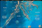
SPOT MAP FORT LAUDERDALE Model: N-220
Top Spot Fishing Maps are waterproof, tear resistant easy to read. Reliable, accurate charts with well-marked fishing areas. All Top Spot Saltwater Fishing Maps have GPS coordinates for Hot fishing locations, boat ramps, marinas and other points of interest. Top Spot Maps indicate types of saltwater fish caught, times of year, types of fish caught, artificial fish habitats, and underwater structure are all shown on the map in an easy to read format.
Manufacturer: Top Spot
Model: N-220
| Specification | Value | |
|---|---|---|
| MFG NO | N-220 | |
| SKU | 6273071 | |
| UPC | 737703002207 |
|
Standard Laminated Map Down River Md#: M00124” X 36” Full Color Aerial Photo Maps Are Laminated. |
||||||
|
|
|||||||
|
PRICE $17.47
QTY
ADD TO CART
|
|||||||
|
Standard Laminated Map Lower Pearl River Md#: M01224” X 36” Full Color Aerial Photo Maps Are Laminated. |
||||||
|
|
|||||||
|
PRICE $17.47
QTY
ADD TO CART
|
|||||||
|
Standard Laminated Map Bayou Dularge Md#: M02024” X 36” Full Color Aerial Photo Maps Are Laminated. |
||||||
|
|
|||||||
|
PRICE $17.47
QTY
ADD TO CART
|
|||||||
Spot Map Fort Lauderdale Model: N-220
SPOT MAP FORT LAUDERDALE Model: N-220Top Spot Fishing Maps are waterproof, tear resistant easy to read. Reliable, accurate charts with well-marked fishing areas. All Top Spot Saltwater Fishing Maps have GPS coordinates for Hot fishing locations, boat ramps, marinas and other points of interest. Top Spot Maps indicate types of saltwater fish caught, times of year, types of fish caught, artificial fish habitats, and underwater structure are all shown on the map in an easy to read format.Manufacturer: Top SpotModel: N-220
Manufacturer Top Spot
Mfg No N-220
SKU 6273071
UPC 737703002207


| 0 | Total: $0.00 |
|
|

